Monday, May 31, 2010

Robert Chisholm of the Whau remembered

I was contacted by a businessman named Tony a while back who said he was interested in buying a small market shop at the corner of Elm Street and Rosebank Road here in Avondale -- was it on the site of the first store? I was able to say yes, give or take a few feet here and there. The earliest known store, going by the Greytown maps of the mid 1860s, was the one just down from the Priestley Brothers and their hotel, and was likely connected with them as part of their 4 acres of land at the corner.

And then, he asked where the name Rosebank Road came from. This is always a tricky question. Many have high hopes for the Avondale trad of the "banks of roses" along the lane, or Mrs Pollen (or some other ardent gardener) tending her specimens of rose banksia). I hate to pop that particular bubble. The sight of hopeful faces falling when there is a more prosaic explanation is not something I look forward to.

Still -- in honesty, I told Tony that the earliest documented evidence we have to hand is that of the Rosebank Estate sale of the majority of the north-western side of the peninsula, which was, up to that time, known as Whau Flats or (later) Avondale Flats. The estate being the property of the by-then late Robert Chisholm. And so Tony asked about him.

So -- we now have a new butcher's shop (apt, as Robert Chisholm was a butcher in Scotland before retiring here to the colonies) named in honour of one of Avondale's earliest, and most enigmatic, land owners.


On top of that, the store itself to which the butcher's shop is attached and is part of, is called Rosebank Market.

Old Chisholm's land was across the road, of course. But, I do like how local history and commercial enterprise can come together like this.

Sunday, May 30, 2010

Remembrance at Waikumete


Back to Waikumete Cemetery in Glen Eden today. I was heading into Henderson for a West Auckland Historical Society function (celebration of the naming of Fuller Lane near Glendene), but -- I have been after a shot of a power board box here for quite some time, so dinged the bell on the bus, got off just up the road, and headed back to the Soldiers Cemetery at the corner, beside the original entrance gates to the cemetery.


The cenotaph was put up by the Auckland Returned Services Association in 1921 for those who served during World War I.

On the eastern face are marked the names of places where the men served: Samoa, Egypt, Gallipoli, France, Belgium, Palestine, Mesopotamia, Salonika. In Maori on the western face: "Kia Ratou I Mata Kia Tu" and "Kia Ora Ai Te Ao."


A seat was installed to the south of the monument by the Victoria League. Just behind is the 1963 memorial to commemorate 57 servicemen of the Auckland Province who lost their lives in and around New Zealand during both World Wars and "to whom the fortunes of war denied a known and honoured grave." A brief look at the Auckland War Memorial Museum's Cenotaph database seems to indicate that many of the World War I casualties on the plaques died at sea while en route to England, at least one within two months of cessation of hostilities. This is another one of those lists of names which hopefully someone can get a bit of time going through the database so that something about the lives that were lost is known to the future. I might give it a go some day.


What kept attracting my attention to this place, however, was the power box artwork.


Those poppies stand out when you're caught in a bit of a traffic jam or, like me, gazing out of a bus window at the surroundings, looking for street art for this blog day by day.

Avondale Train Station, number three -- coming soon


My I-can't-wait-for-it day as far as June will be ... the re-opening of the Avondale Train station on 14 June. The new station looks to be pretty standard stuff, but -- it'll be new, not far for me to trot down to in order to catch my favourite mode of public transport, and ...

... I'll get my access back across Crayford Street and the rail line to Great North Road. Which I have missed, quite terribly, these past long weeks since they closed it again.

So ... yay!

Friday, May 28, 2010

Henderson box art


Three more examples of control box art in Henderson.

At the corner of Sturges and Swanson Roads, the huia bird lives on amongst fairly tropical colours.


At the corner of Great North Road and Buscombe Avenue, it's gone a bit botanical.


And at the corner of Great North Road and Alderman Drive -- the wetas rule.

Thursday, May 20, 2010

More on Oliver Alfred Rayson

Further to earlier post: In Search of Oliver Alfred Rayson. John from NSW's Blue Mountains has kindly reported back on his findings with regard to Mr. Rayson. There's more pieces to the puzzle, but still some gaps. However, now we are a bit more informed about both the Avondale Rayson and the Sydney one -- it's just still not proven that they were either one and the same, or related. Many thanks, John, for taking the time to look into this!

Dear Lisa,

Well, as promised, I went to the NSW State Records Office last Monday and checked out the Deceased Estate file for Oliver Alfred RAYSON and also did some further miscellaneous research on him. Your man has caught my imagination and being responsible for such a large number of horses involved in the omnibus business, is not altogether unrelated to an area of research I am interested in at the moment – the history of animal welfare.

Anyway, to the Deceased Estate file first! While this did not provide any confirmation of his New Zealand origin, it did give his full name as Oliver Alfred RAYSON and his wife’s name as Catherine Margaret RAYSON and provided some interesting detail about his estate.

His estate was valued at £485 and consisted of: £26-5-0 worth of shares in the Sydney Tramway & Omnibus Company Ltd; £100 deposited in the Savings Bank of NSW; £7-4-4 of interest on these savings; a policy with the Colonial Mutual Life Insurance Company Ltd worth (with bonuses) £349-7-0; one milch cow valued at £2 (probably the one that later went wandering!). On the debit side he owed a debt of £2-7-4 to the Colonial Finance Mortgage Investment & Guarantee Corporation Ltd.

Though not mentioned as part of his estate in the above file, I later found an auction advertisement placed in the Sydney Morning Herald, 7 December 1896, on the instructions of Mrs. Rayson that included considerable furniture, glass, china and electroplate, a pianoforte, carpets, engravings and watercolours and other household items.

A further advertisement I located in the Sydney Morning Herald, 22 August 1889, that sheds some light on the affluence of Rayson at this time is one placed by Mrs. Rayson: “General servant required, good wages, Mrs. Rayson 1, Lancaster Villas, Ocean St. Woollahra.”

Now a look at some further odds and ends I discovered from poking around a bit more:

It appears that Rayson may have gone from New Zealand to Melbourne before moving on to Sydney. In the index to Victorian BDM I got one match for a marriage between ‘Oliver Rayson’ and ‘Catherine’. You have to pay on-line to access the details so I will wait until I next visit my local library (where I used to work) where they have it all on CD-ROM. However, I am pretty certain this is our man as I also came across a notice in the Sydney Morning Herald, 9 August 1895, for the death of Catherine Rayson’s sister at her home in Richmond, Melbourne. So, it would seem that Mrs. Rayson came from Melbourne. (No marriage for Oliver and Catherine came up in the NSW Index.)

It appears, also, that Catherine was not Oliver’s first wife! I had a quick look at the NZ BDM Index and found a baby girl, Eliza Mary, born to Oliver Alfred and Sarah Agusta (sic) RAYSON in 1875. (Eliza died ten days later.) Couldn’t find their marriage so went to the International Genealogical Index (IGI) and up came a marriage between Oliver Alfred RAYSON and Sarah JONES at St. Paul, Deptford, Kent, England, on 27 November 1858. If this is our fellow I wonder what happened to Sarah between 1875 and the Melbourne marriage to Catherine (for which I don’t yet have a date)?

While I was at the State Records Office I also checked the Sands Sydney Directory for the earliest date of Rayson’s appearance in Sydney. The first entry for him is in the 1884 edition, suggesting that he began his job as Manager of the Omnibus company ca.1883-84.

Finally, the NSW Index to BDM shows that Catherine Margaret and Oliver Alfred RAYSON had five children in NSW – Sidney (1884); Ruby (1886); Katherine M. (1888); Alfred H. (1890); and Harold G. (1894).

The NSW Index (Deaths) records Oliver Alfred RAYSON’s parents as Oliver and Louisa.

So, for the moment, I’m afraid that’s it! I hope it’s of interest and you can make something of it all. I will certainly pass on anything further I might come across. We don’t know for absolute sure, of course, that the Kiwi Rayson and the Aussie Rayson are one and the same and I think we might have to get a copy of Rayson’s death certificate to prove this categorically.

With very best wishes,

John

Sunday, May 16, 2010

Looking for McLeod's Crossing

As I've mentioned before, my quest this year is to complete a bit of a history of Henderson's Mill, called Timber's Fortune. This means that most of my visits to Mill Cottage, the base of operations for the West Auckland Historical Society, tend to involve discussions with local historian Ben Copedo. Who, one day recently, referred to McLeod's Crossing.

Which I hadn't heard of before.

Righto. That was on my list of places I needed to see, next time I was in the area. Which was last Monday, where I decided to take the other route along Edmonton Road way to Mill Cottage, instead of the more direct Ratanui Street route.

On the way -- other things were found. Always a mark of a good journey, when other things are discovered along the way.


Newey's Corner (right in the photo), 1930s, from the information plaque in the reserve on the corner of Edmonton and Great North Roads. There used to be a house there, owned by Eileen Newey, a schoolteacher. When she died, the Henderson Borough Council got the land and the house.


The land is now a pretty little reserve and walkway beside the Oratia Stream. The house, put up on offer to any community group who wanted it in 1987 ...

Image: Western Leader, 28 September 1987

... but somehow the house ended up at Western Springs, beside the Auckland Horticultural Society building, Great North Road. Almost opposite Motions Road. I still don't know how, or why, but I'm working on it. Any information gratefully appreciated.

Update 30 December 2011: I now know -- but too late for the fate of the cottage. See here.


The Oratia Stream, from the Alderman Drive bridge (built 1984).

Next, a point of contention still in Henderson's local history, although I'm not sure why there is still so much utterly mad misinformation floating around about it, after all this time: the Falls Hotel.


This was built, originally, in 1873, on Great North Road close to Railside Avenue. So says Ben Copedo, so says enough contemporary newspaper references to surely win the argument. But, while there is still strange bad history around like Graeme Murdoch's Field Guide to Auckland (giving an unexplained date of 1856)  and the website for The Falls itself (1854) -- folks will still think this is one of the oldest hotels around. And have the wrong information to boot. Why does the 1850s date refuse to die? In 1854 (early, and before Long John McLeod leased the mill from Henderson & Macfarlane), there was a survey done by Commander Drury on HMS Pandora of the Waitemata River and its tributaries (Ref. NZ Map 3909, Auckland City Libraries' Maps Online.) It showed some blotches on the Opanuku Stream, plus the word "Mill" beside a larger blotch. This couldn't be the saw mill, the historians said, because it's on the wrong side! Has to be an error. Hmm. Wonder what it might be. Oh, how about a hotel? Yes, it must be the Oratia Hotel, built 1854, by Long John McLeod who hadn't quite reached the place just then ...

Actually, there's nothing against the original saw-mill having been on the other side, as Drury has it, because McLeod had to build a new mill by bracing up the old one to cut the timber ... Ah, well. Heritage urban legends are hard to kill.

Some more shots of the hotel, altered greatly since 1873, and now shifted to Alderman Drive (since 1996). They may try to link the hotel to "Long" John McLeod, but it's "Shepherd" John McLeod who built it, was the first publican there, and now it's on the farm he ran from the 1860s, Mill Farm. Very apt.


A band rotunda was added to the hotel's landscape on Falls Park in 1999.


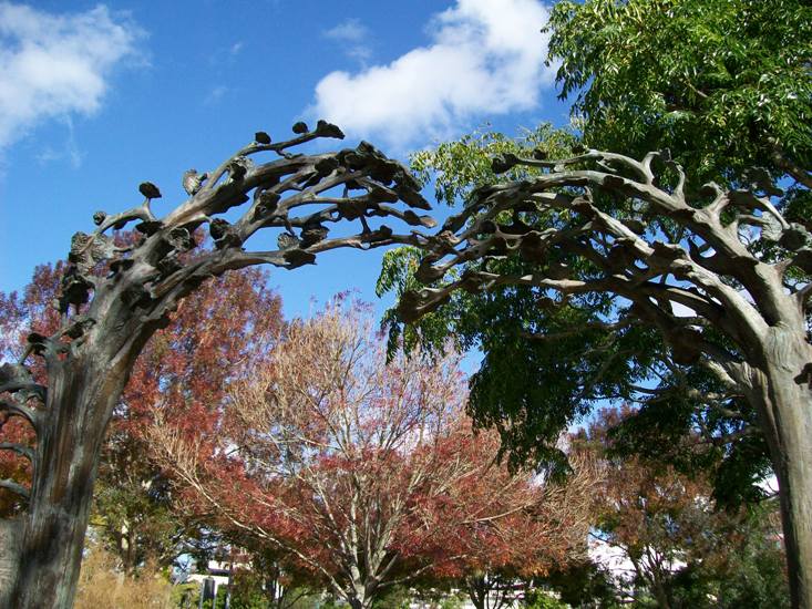
This is a sculpture by Roderick Burgess, installed 1998 at Falls Park, showing the history of primary and secondary industry in Henderson.


Gumdiggers.


Winemakers.


Click to see more detail. Email me if you'd like to see higher res shots. This sculpture is very detailed.


I couldn't find the Volunteer Camelia (hopefully, it hasn't been ripped out or vandalised).


But I did find the Rotary Peace Garden, dedicated in February 2000.

And then, going over a small wooden bridge ...


... I realised I'd found the subject of the search: McLeod's Crossing. The only way I knew was because of a small, circular bit of bronze set in the centre of the walkway. I nearly missed it.


A bit of a shame, as this is a crossing to the Mill Farm, closely linked with "Shepherd" John McLeod, hotelier, farmer, horse-breeder, Highway Board member, and one of the pioneers of the district.


The bridge was designed by Karekare artist John Edgar, and was reported at its opening in 2000 to reflect "elements of a kauri tree". Not sure how that reflects back on "Shepherd" John McLeod, but -- at least it does mark, in a way, the path to his farm. They probably didn't want to put anything more than the bit of brass in place with a name on, in case folks started arguing over this bit of Henderson's history as well ...